Friday, June 28, 2013

MTA (Mobile Trail Angel)


Sierra City (Tahoe Natl’ Forest) – Buck Lake (Plumas Natl’ Forest) -­‐ Chester (Lassen Natl’ Forest) mile 1197 to mile 1310

This weeks email is from Maureen, aka Chief’s wife.
My lifesaver.  Half mile App.


At my last “goodbye” at Red’s Meadow, outside of Mammoth, I realized I wouldn’t see Kevin again until I flew to Portland on Aug. 19 to drive out to Timberline Lodge, where I am to meet him for 2 zero days at the Lodge. This was a rather emotional goodbye. Until....Kevin suggested that I do a “road trip” through the Northern Sierra and Southern Oregon section of the trail. I’m off work for the summer and had a dear friend lend me her truck/camper combo, it seemed the right thing to do. It sure is!
Great Mtn. Highways
The boys in a BED!


Reunited with Bodie!

Trail Magic from Grandma Pat

Red Moose Inn


Enjoying Pat's Trail Magic
Having mimosa's for breakfast, Day 1!

NEEDS NEW SHOES


NEEDS FOOD

NEEDS UPPERBODY muscles

Hello PCT!


MTA


Wild Plum Campground – Tahoe Natl’ Forest
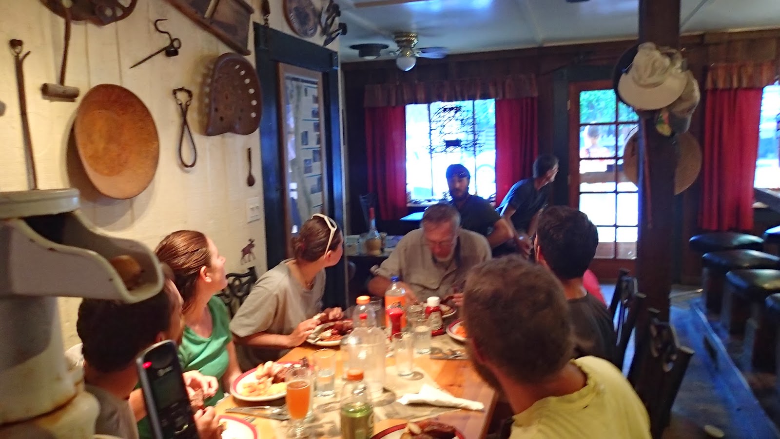
Met Chief first night at Sierra City at the Red Moose Inn (trail Angels in Sierra City). It was a great start to my road trip. Got to meet up with about 8 of the thru-­‐hikers and had a wonderful evening eating, drinking and chatting with all these amazing people that Kevin has been telling me about for so many miles now. Bill and Margaret, owners of the Inn and Trail Angels extraordinaire were wonderful hosts. Shared some great trail magic from Grandma Pat and Dana at the Inn for all the hikers. They are so grateful for all these “care” packages. We stayed at a FS campground about 1 mile from the Inn along a fork of the Yuba River. It was pristine. Kevin has a zero day the following day and we swam, relaxed, told stories and I continued to feed him lots of food.
Red Moose


Closed the Cafe for our Private Party!

All the ribs you can eat - Bill and Margaret

The party

Dropped him off at the PCT trailhead from Sierra City along with a couple of other hikers, Roger Dodger and Dora. Plan was to meet him in 2 days later at Bucks Lake, outside of Quincy. This is when I heard the news (through cell phone coverage) regarding the Granite Mtn. Hotshot Crew out of Prescott, AZ. It is horrific, awful and unimaginable how something like this could happen. I wasn’t sure where Shane’s crew (Los Padres Hotshots) was and was worried sick for him also. Not to mention our close connection with a member of the Granite Mtn. Crew, Sean Misner. He is a part of our Montecito Fire Department Family, as he is the nephew of Terry McElwee, Division Chief MFD and grandson of former Chief Herb McElwee. We have known this family for over 20 years. I can’t remember when I’ve cried as much as I did that day. I decided to contact Kevin via his satellite locater and tell him the news. I felt it was important for him to know. We somehow were able to communicate that he would meet me on a forest service road that intersects with the PCT in the mtns beyond Quincy. I got there about 2 hours early and hiked the trail with Bodie. It was wonderful to see hikers coming down and letting me know that Chief was not far behind them. Most of them know Bodie now and he is the greatest greeter when he sees a hiker! When we met it was very emotional. He had heard some of the news from Whistler, who carries a portable radio, but was not aware that Sean was part of the crew. After hiking together for a few more miles, we decided it was best for Kevin to stay on the trail and continue his hike. The trail is a magical place and very suited for mourning this loss in one’s own space. Our hearts go out to the McElwee/Misner family and especially his wife and unborn child. Words are not enough to convey our heavy hearts.
Saying goodbye after a couple of hours, he was back on the trail and put in a 31-­‐mile day. Walking seemed the only way to manage his emotions. When he arrived at the Feather River that evening he was exhausted, but greeted by his fellow hikers, they all sat and talked about what had happened. Somehow this was the right place to be. 

Whitehorse Campground – Buck’s Lake, Plumas Natl’ Forest
Bucks Summit

Picked up Kevin in the late afternoon at the trailhead near Buck’s Lake. Made lots of food and had lots of beer, snickers, cookies, ice cream, chips, hotdogs !!! Things we would not eat at home!! JULY 4! Drove to the summit to get cell coverage so Kevin could talk to Shane. That is what he really needed at this time. Shane told us about MFD donation at the Pancake Breakfast for the Arizona Crew and how they made the front page of the New’s Press. I’m so proud to be a part of such a great Fire family. Thank you Montecito Fire.
Belden Town – Caribou crossing campground/RV park, Plumas Natl’ Forest
Wow. Let me tell you about Belden Town! RAVE party every weekend along the little 1⁄2 block that is Belden Town. It runs along the north fork of the Feather River. Many years ago Kevin was on a fire here and remembered it as a Resort. Well, no more. It’s a RAVE party weekend getaway. The PCT drops right down into the little haven of craziness. I was lucky enough to see naked, hula-­‐hoop dancers along with music at 5am this morning as I dropped Kevin back off on the trail. Interesting. Wow. Love the mountains, but there are some interesting things going on up here?


Chester – Hwy 36, Child’s Meadow RV park, Lassen Natl’ Forest
Left Belden after dropping Kevin off at 5am to start his BIG climb out of Belden. It is a 5000 ft climb with no shade, due to a recent fire. For all you locals, that’s like doing Little Pine twice in the heat! Or climbing out of the Grand Canyon... And it’s hot here. High 90’s, dropped about 10 degrees from a few days ago. He’s hoping to do a regular 24-­‐mile day and then a second 24-­‐mile day tomorrow where I will pick him up at Hwy 36, where the PCT crosses. I’m staying about 18 miles south of Lassen in a beautiful meadow RV/campground. Took Bodie on a 6-­‐mile hike today where we were in the constant “WOW” factor. Huge meadows with thousands of Shasta daisy’s, waterfalls, creeks, big forests, just gorgeous. This is definitely riding country and I so miss my horse. There are public pastures all around with very few riders to be seen.
Will stay here for a couple of days until I am able to pick up Kevin again. He will spend the night and then off to Drakesbad, mile 1353....the unofficial
HALFWAY point. Rumor has it there is a great party there for just that reason!

The Belden Bridge

Our happy little mobile home

A proper meal with a soft cushion to sit on

Leaving for a few days of walking
I am so grateful to be able to do this. I love the PCT community. The hikers are more than amazing. It is so great to be able to pick up hitchhikers that I have met
along the way. It’s so hard for them to get into towns to pick up their resupply boxes at the Post Offices. Most of the time, people tend to believe they are homeless bums, or vagabonds, etc. That is the hardest thing about the PCT. The idea’s one makes about the hikers. Truthfully, I have to say that I would never pick up a hitchhiker around SB carrying a backpack and looking like they’ve lived on the trail a bit too long. This time of the year, most of the local folks in trail towns are familiar with the thru hikers and will help out in many ways, but still not easy. I need to live near the PCT so I can be a Trail Angel for a couple of months every year.
This trip is like a huge scavenger hunt. I love trying to find him along the way. Where will that, oh so familiar, PCT placard be? Thank goodness for my iphone and my handy, Half Mile App. It just gets you right where you need to be. My life has slowed way down. Very simple...find Chief, feed Chief. And the bonus is I get to see a beautiful part of our country and get to see my walking man every few days!

Many, many thanks to Jeanette for trusting us with her camper. We are ever so grateful and I so wish you could hear Kevin say, “Thank You Jeanette,” every time he gets to sit on a soft bench or sleep in a bed or shower with warm water and soap.

Maureen
Aka “Chief’s wife” 
Some little critter had a good time with Chief's hat

Friday, June 7, 2013

Sierra Zephyr

 mile 907 to mile 1197 (almost 1200!!!)


Having a nice breakfast with Maureen and Casey

Seeing PUMA again!

Backup, Puma and Chief
Leaving Red’s Meadow was a bit of a challenge as it is always hard to say goodbye. As Casey and Maureen left, I was off on the wrong trail for a good 2 miles. Once I got on the PCT, walked through all the tree damage from Red’s Meadow and Agnew Meadow before going over the beautiful High Sierra Trail. Coming into Tuolumne was a shock. It’s amazing how when you leave Tuolumne you enter complete wilderness. Go beyond Yosemite 5 miles in either direction and you see no one. 
Red's Meadow

Beer Tasting with Casey


From Glen Aulin I walked 27 miles that day. I saw one bear that was eating breakfast and I nicely asked him to please go away. Saw 1 backpacker. The PCT trail is not very well marked nor maintained through Yosemite National Park. Apparently, Yosemite is not so keen on the PCT going through its park. Stopped at the Tuolumne store, but there was way too much civilization for me to stay. Some crazy lady slammed the door on my foot and ripped the top of my shoes. I left.

Early on in the year when I sent my first email out regarding my Re-­‐Supply, Rich Phelps noticed I made a big mistake. Somehow I got my mileage wacked out from Sonora Pass to Echo Lake. Had only a few days of food for a big stretch of miles. Fortunately for me, the Phelps’ volunteered to resupply me at Sonora Pass and Echo Lake. They were on for a road-­‐trip! Sure enough they were there waiting for me at Sonora Pass and provided Trail Magic for other thru-­‐hikers. It was a nice visit with a hot shower and sandwiches and charges for all my electrical needs. All I did for them was provided a couple of sprigs of “Sky Pilot.” Cowboy had his 30th birthday on Sonora Pass and they were singing right along with all of us. Then the weather changed. Leaving Sonora Pass there were rumors of a storm. The first day out it started to drizzle and get a bit cold. Then came the Sierra Zephyr! (Terminology that the Nat’l’ Weather service uses for a strong High Sierra Wind, resulting from an unusual summer storm). When they built the PCT, they took it seriously and put the trail on the CREST of the ridge...so when the Sierra Zephyr blows at 70 – 100 mph on the ridge tops it completely hammers you on the trail. There is NO way to get off the ridge. You have to walk, crawl, struggle or lean into it. The first day I felt confident that I was ready for the upcoming Washington weather. It wasn’t until the second day that my confidence got beat down. I should have stayed in my tent all day, but...along with 2 other couples, we decided to go to Carson Pass and beyond. BAD IDEA.
Dinner with the Phelps after my RESCUE

By the time I was on a ridge about 8 miles from Carson Pass, I received a text from Rich asking if I needed anything (as they were camping through this crazy weather event), I said, NO. Mountain Man, Bad ASS only lasted 1 mile. Texted Rich, “Please Mr. Phelps, come and get me!” I was hypothermic, my hands weren’t operating right and I really needed some serious moral support to get through. By the time I got to the Pass and the Phelps picked me up, my spirits picked up. And for all of you that are following my map, that is why I was in Gardnerville. Never so happy to see a Nevada town in my life! No zero day, just a warm shower, Italian dinner with the Phelps and a really nice bed! That was the Sierra Zephyr. It was the closest I have ever felt to being mentally broke. Thank you Rich and Kathleen.

Good Morning PCT! The next day was stunning. Lots of water, hiked down to Echo Lake. Camped above the lake and was able to see Lake Tahoe. I now have a customized PCT hat, as some little critter chewed up my brim! All the girls think I need to keep wearing it. They explained that people pay lots of money for clothing with holes in it. Then walked 120 miles through a super thick forest. Big trees becoming more and more dense as you walk on. Early on mosquitoes were bad. No more bears, but did hear some deer munching near my tent one evening.

Getting excited to see my PCT groupie wife in Sierra City, I did 24 miles in 8 hours with a long lunch break. Got in early afternoon to the Red Moose Inn and Café, a small 100-­‐year-­‐old tavern (Dad you would have LOVED the bar!) run by Bill and Margaret. We began our PRIVATE party with Cowgirl, Midnight Chocolate, Julian (the flying Swiss kid), Lodge Pole and Maverick, the father/son team from Santa Cruz. They were so cool and exactly the same ages as Shane and I. Such a nice time I had with them, made me miss Shane a lot. Grandma Pat’s Trail Magic was a hit! Everyone enjoyed the cookies and thought that she should open “Grandma Pat’s Cookie House!” We had a private party and Bodie was able to join us in the café. Bill BBQ’s all you can eat ribs and Margaret is as sweet as ever, continuing to feed us all. All the girls LOVED him and remembered him from Lake Moreno. We had a weigh off at the bar to see how much weight we all had lost. The girls didn’t seem to be loosing as much weight as the men. I’m at my high school weight and not looking too good. I keep eating everything and anything, but not seeming to catch up to my daily caloric needs. Hopefully the next 2 weeks with Maureen’s cooking, I will do better?

Doing about an average of 24 miles per day. For the next 500 or so miles, Maureen and Bodie are my little honey wagon. This Northern California section works a bit better as I can see her along some little roads and she can pick me up for the night. No big zero days, but excited to have a nice dinner every few days with her. Thanks to Jeanette, she is driving her truck with camper. My personal 5 star HOTEL! Thank you, thank you Jeanette. Lot less anxiety for Maureen than pulling the Airstream on these roads and small Forest Service campgrounds. The campgrounds are pristine here in Northern California. As I sign off for the week, I am at the Wild Plum campground, along the side of the Haypress creek, sitting in a CHAIR (doesn’t happen much) eating Dana’s Trail Magic cookie bars (sorry Dana, they are way too good to share!), my trusty dog laying on my side and looking up at the Sierra Buttes, which I have to climb tomorrow morning on my 93 miles to Belden, where I hope to see Maureen again.

Chief

Saturday, May 25, 2013

SeaLevel, the Sierra's, and THANK GOD for the John Muir Hut


Sierra Passes and Rivers – mile 744 to mile 907

Shane’s roommate and lifelong friend, Ari, decided to join me for the majority of this section, which is most of the John Muir Trail. He arrived from sea level to Lone Pine, where Maureen dropped us off at Horseshoe Meadows to start from Cottonwood Pass to meet up with the PCT.
As we were leaving, we met Billy Goat...the Icon and Legend of the PCT. What an amazing man. He lives on the PCT until winter and then hikes in the southern states, typically Florida. Billy Goat is a wise old soul who anointed Ari with the trail name, Sea Level.
Chief and Stagecoach
The Passes. So this segment has 7 named passes. Forester, Glen, Mather, Pinochet, Muir, Selden, and Silver, 5 of which are technically challenging and all about 12,000 ft or higher. Forester is the tallest and additionally, the highest point on the PCT standing at 13,180 ft. 
Additionally in this segment you have the potential for treacherous river crossing due to snowmelt and strong currents. Everyone is nervous and apprehensive about these passes and river fords. A lot of energy is spent on these issues. We are constantly asking other PCT hikers that may have heard rumor about the in’s and out’s the next 200 mile segment. “What about the ice-­‐chute on Forester?” “How about the potholing?” “River crossings?”

Calories. How many calories can I fit in my Bear Box? How many resupplies will I need to get from Kennedy Meadows to Mammoth? Do I travel fast to get more food at the difficult resupplies? Strategies all revolve around food. Conversation on the trail revolves around food. Food takes over our world. This was the longest resupply on the PCT – mile 702 to 907. No resupply on the trail for 205 miles. You have to make decisions on calories and food. And always with the limitations of that darn Bear Box.

Play time. We had a Pool Party in the late afternoon at Grouse Meadow. The middle fork of the Kings River meanders through a high sierra meadow, very similar to Yosemite, although on a smaller scale. The current runs at about 2mph. We floated down the river, ran upstream and jumped in again. There were nine, skinny, hungry, thru-­‐hikers as playful as elementary kids at a pool party.
First day we walked 16 miles leaving Cottonwood Pass. Sea Level needed a relatively easy day to get adjusted to the elevation changes. No big passes nor river crossings, just a day to get used to his pack, shoes, and my walking speed.


Muir Pass. Well, it was quite a day. Hard to really describe this event. June 10, 2013. We needed to crest Muir Pass before noon otherwise the post-­‐holing on both sides of the pass would be so difficult that we would expend 10 times the energy per mile. The problem was that the approach to Muir Pass was a long and steady climb. We started early, although it was still a climb to do before 11am. The rest of our “play-­‐mates” has started ahead of us. Muir Pass is actually an East-­‐West pass, so as we turned the corner to get a view of the pass, we see big, black cumulous storm clouds building over the pass. That is when my throat dropped in my stomach. I knew we needed to push the pace to get up and over the pass before the Storm hit. The problem is that we were now in snow and rock and couldn’t find the trail.
There were snow bridges that we needed to be extremely careful not to fall through. We needed to walk through snow fields that were steep and slippery and we needed to walk carefully that we wouldn’t fall into a rock pile or river and we were trying to navigate in a hurry to find the trail. I made it to about 300 yards from the crest of the pass, when grapple starting falling, where Muir Hut (a granite stone hut that the Sierra Club built in 1930 for a safe refuge from storms) was finally visible. My the time I reached Muir Hut, it was a full snow storm. Sea Level was still behind me. I had been continually urging him to continue to push to crest the summit. I couldn’t see him coming. All I could see was a horizontal flow of snow. I stepped into the hut to a cheering of 7 PCT hikers. “Yay Chief! You made it!” “Where’s SEA LEVEL?” “ It’s his Mother’s birthday. He has to make it. I don’t want anything to happen to him today!” They were encouraging and then I saw the top of his hat. Baxter ran out to get the heroic photo op of Sea Level cresting the pass, but he approached from the backside of the hut! The photo will remain in our memories. It was a great moment. 9 happy refugees from an early Sierra summer storm together in Muir Hut. Much to our shigrin, Muir Hut LEAKS A LOT! We put our raingear on to avoid the drips. We pulled out our stoves and made Mocha’s with our Starbucks and Hot cocoa mix.Best Mocha I ever had. Then the jokes started and we all acted like we were never scared. After about an hour, we settled down and Wild Cat read from her kindle the “Ghosts of Muir Pass!” A story from one of the PCT readers. So as she is reading, one of the possibilities of how the Ghost dies was a lighting strike. We immediately hear a loud thunder clap. We all closed our mouths, opened our eyes and exclaimed, “Did we really hear that?”
Birthday note to Michelle!

The storm slowed down after about 4 hours. 7 hikers decided to brave the wind and the cold to try and get down off the pass. Ari and I decided to spend the night in the Muir Hut, although it was damp and still dripping, it was the warmest and coziest night I have ever spent in the Sierra’s. We woke up to a cold blue bird sky with sparkly new snow and we were able to descend the pass on a wonderful, Sierra day. Quite a memory I will always cherish. I was extremely proud of Ari. He reached deep down and didn’t panic and did what he had to do.
The 7 that went ahead were worried about us and we were worried about them. When Ari and I walked into VVR (Vermillion Valley Resort) for our resupply, there is an outside bar. There we had a happy reunion -­‐ 2 different strategies that both had good outcomes. We cheered and hugged. It was great. Beers flowed and stories were told.
Muir Hut, after the storm

I am so thankful for friends and family. Greg and Tom who delivered my resupply at VVR (the “Indians!”), Maureen who has continued to make my food, prepare my resupplies, and to all of you that are following my walk. Thanks again to the Phelps who are getting ready for my next resupply, thanks to those Trail Magic cookies! It really all makes a huge difference. And a big thanks to ARI! You were amazing. I am so proud of you. I hope the magic of the PCT has given you some insight into your life.
Ari (SeaLevel) on Forester Pass ledge of death


SeaLevel

And now for a bit of philosophy. Something I don’t generally share but this trail has a way of doing things to you.


As you share your stories with fellow PCT hikers you eventually talk about the motivation behind walking the PCT? There is the youngest group just graduated from high school and don’t want to move further with their life until they have an adventure. There’s the “20 something’s” that have graduated from college and don’t want the choices and responsibilities yet. They are trying to decide what is important to them? The midlife’s who want to make some changes in their lives, either with their careers or their personal life choices or both. The latter years, like me, who are struggling to get one more adventure in their life!
I have been thinking a lot about what my motivation is. I think that some of my motivation was to reflect on my life and my career, my choices and questions the why’s of some of the decision’s I’ve made. Is my compass in the same direction that I can live with at this time in my life? I feel like my moral compass is in the right direction, but I think I question should I have taken different decisions or directions. Now I have time to reflect on the choices I have made and make possible changes if needed? I have always had the weight of “responsibility” on my shoulders. The day of Muir Pass, I not only had the responsibility of my survival, but also of Ari. I realized that that responsibility is part of my make up and although it weighs me down, it also empowers me. It is who I am.

Chief
It is who I am


Home Sweet Home

Lunch time


Pictures to follow...from Ari! 

Friday, May 10, 2013

The First 456


HI from mile 456! 5 Rattlesnakes, 1 bee-­‐sting, sore feet, 7 Blisters, trips but NO falls.

I walked into Aqua Dolce on Thursday afternoon after camping the night at Soledad Canyon. The KOA was not far off the trail and we all caught sight of a pool. Great stay for $5. Soaked in the Jacuzzi and swam in the pool. The trail comes under Hwy 14, such a long drainage tunnel that by the middle you can’t see anything. You come through Vazquez Rocks State Park. Quite nice. Taking a few “zero” days at our friends ranch. The MJF Ranch. My own personal “trail angels.”
Martin and Jackie's Ranch in Aqua Dulce


Welcome to the Saufley's
The official “trail angels” in Aqua Dolce are the Saufley’s.
 I took Maureen by their house so she could both meet all the thru hikers I have been telling her about for a month now, and just to first hand see what a trail angel house is all about. She took a lot of pictures. It was pretty amazing. This trail has so much more to offer than I ever knew about. This is why Shane had such a hard time leaving the trail. This is what is making this trail so special for me in so many ways. The Soufley’s are such nice people and when you check out the pictures, you will understand what I mean. To walk every day, 20 plus miles/day and then to arrive at the Soufley’s...wow. The hikers. OMG. All ages and from all different walks of life. Iceman and Kattywampus, Tumbleweed, Craig, Ducky, Tank, the Wild Boys, Smooth Operator, Buzz, Yoga girl, Happy, Yard Sale (the youngest so far, 18 year old from Washington, DC) and so, so many more.

The Resupply Boxes

Info Board

Laundry

Katywompus and IceMan
Saw people eat more food than I ever thought possible. Maureen was able to be a “trail angel” shuttling hikers and backpacks from Vazquez Rocks to the Saufley’s. She loved to meet and chat with all them. I know this made her feel more comfortable knowing that I am among all of them. We may not hike together every day, may not see each other for a few days, may hike together for 10 miles, or we may all sleep in the same area, but either way, we all look out for each other. We all go by our given trail names. Maureen called my name in the grocery store and everyone turned to see. “Chief” is that your name??? Trail names have to be accepted and some won’t get their names until a few more weeks. But, they are given on the trail by other hikers. Kevin was given Chief by our friend, Paul, who is a section hiker.

Some highlights of my 465 miles.

The coldest day – North of Big Bear Lake above Cougar Crest. Wind was blowing, light rain. Only got 15 miles in until I had to set up tent among the sugar pines. Cooked Spring Onion soup in my vestibule and pulled my spirits up and got inside my really expensive bag that I didn’t feel quilt about any longer. Woke up to 25 degrees. Condensation had frozen solid on the inside of the tent. No breakfast, no coffee...just started walking to get warm. At the end of 22 miles, I went to put up my tent and still had ice inside!

The hottest day – too many to decide from! One that was memorable was walking out of Cabazon (Ziggy and the Bear) climbed about 5000 ft – low desert, NO shade and you just keep walking alllllll day long. There was one stunted sycamore tree
along Mission Creek. Arrived to find Lion King and other hikers all hunkering down under this pathetic bit of shade.

A bad moment – arrived in Warner Springs. A great feel of hikers. Felt good. My first off trail experience with Trail Angels and showers and food. Now I had to say goodbye to Shane and Maureen and go back to the trail. I did two full circles around before I could find the northbound trail ...it was a hard day emotionally.


The wonderful people at Warner Springs Community Ctr

My biggest surprise about the PCT – Trail Magic and the people. Trail Magic is just an act of kindness, an unexpected gift. Shepherd is a trail angel. Walking through Deep Creek, coming down into Palmdale/Victorville. Mojave River overflow, looking very parched and sad. Coming around the corner in the sand. There is Shepherd with a camp stove. She cooks hotdogs, makes root beer floats, crackers, fruit and candy bars. Trail Magic.
Recliners with soda on the trail. Ice chests on the trail with fruit, veggies and cold sodas. Trail Magic. 
The Party under the Scissors Crossing

Cajon pass over a 600 ft climb up to Mt. Gregonia. 19 miles. HOT, exposed and waterless section. Come around a corner and there is a wooden cabinet with doors. Open the doors and there are gallon jugs of cool water and a sports illustrated with Kate Upton on the cover. 2 chairs in the shade. Sit and read Sports Illustrated with a cool cup of water. Trail Magic.
Picnic Table at Guffy camp. Dinner party with 8 PCT hikers. Sitting on a bench was so nice. No rock sitting. We talked about other hikers and strange things we’ve seen on the trail. Purple Haze had his tent set up with a WELCOME mat and a porch light (aka, head lamp strapped to his pole!). Amazing people.
Shane on Eagle Rock 
Water Cache - Trail Magic

The Trail –The intent in designing and planning of this trail was to keep it primarily on Public Lands to avoid easement conflict and private land owners, so, often it will wind around instead of a direct line. The trail may end up being i12 miles when it could have been a 2-­‐mile direct hike. Maintenance and upkeep is dependent on each land management agency. The condition of the majority of the trail in the Angeles Nat’l’ Forest is dismal to poor. (Makes the 40-­‐mile wall off of the Santa Cruz trail in the Los Padres look good!)

Trying to be Alone-­‐ Believe it or NOT, Its hard to walk and camp alone on this trail. Although I like to walk and chat with people, I do enjoy some private time. One day, I stayed on the trail instead of going down to a trail angel. I camped by myself. Met up with Catawampus a couple of days later. She was upset. She looked for me, was worried about me. When she and Ice Man finally found me, they were so happy. I just told her, “it’s okay Catymompus, I just needed bit of alone time, I will never do it again!” Nice to know everyone is looking out for one another. Maureen would be happy about this.

Zero Days = Zero Miles -­‐ This might be a campground, a resupply town, just a place to be with no miles. It might be a, much needed, mental health day. I had a sanity check on the trail a few days back. Some days are very long and you begin to
question your sanity. This happened to me coming out of Cajon Pass. I saw 2 guys walking in white cotton thermal underwear (the old kind). So at the “dinner party”, I did a survey and out of 10 people, only 2 of us saw them. So I figured I was 20% sane? It was a strange site.
Zero days may be needed for sanity, sore feet, blisters, mental, sunburns, or you just might come across a cold creek and decide this is the place to rest. Feet and water are huge in the desert. You have no idea. Feet aren’t meant for this much pounding, day after day. No water to wash or soak in. Hot, rocky, trails. Everyone learns to deal with his or her feet through these early sections.

Things I thought I would never do -­‐ Walk into somebody’s backyard that you never met. Some 81-­‐year-­‐old man (Bear) brings you a hot, Epson salt bath for your stinky, dirty feet. You take a shower in their shed/shower room, eat a big bowl of wonderful, green, crisp salad provided by Ziggy. Then at night you lay down on a carpet in their backyard wedged in with 20 other hikers, like you did during preschool naptime. Meet Ziggy and the Bear – Cabazon, California.
Sleeping in the backyard!

The Best Graphic – please check out the elevation profile (picture) that includes the San Bernadino and the Angeles Forest. I never expected this in the Southern Calif. Mtns. I know about the Sierra’s, but this was a shock. Hot and up and down and up and down. A bit discouraging. You just keep looking down, not ahead. I have learned NOT to look at my elevation maps.
Up and Down and Up and Down

I miss Maureen and Erin and Shane. I don’t miss Bodie! I’m surprised that I don’t miss my home, the beaches, my trails, my life. I am having a great time. I’m off to Canada! Thanks for all the support at home. Maureen tells me about all the emails that she gets, concerns, diligent map followers and phone calls. I am so grateful for all your support both for myself and for her. 

This is what friends and a community are all about. Thank you.
Ouch.


Chief